Fitz Roy Trek: Guide to Laguna de los Tres
Book an experience
Guided treks & hikes
Book a guided trek: gear, route knowledge, and safety handled by experienced local guides.
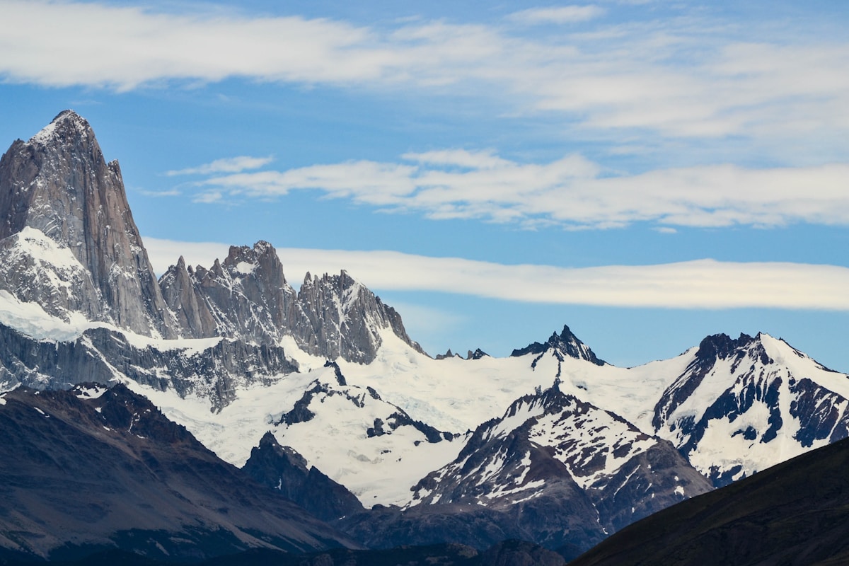
The trek to Laguna de los Tres is the single most popular hike in Argentine Patagonia and one of the most celebrated mountain walks in South America. The objective is a glacial lake at 1,170 metres above sea level, sitting directly beneath the granite towers of Mount Fitz Roy (3,405m) - a peak that was first summited in 1952 and remains one of the most technically demanding in the world.
The hike begins in El Chaltén, a small village in Santa Cruz province established in 1985 specifically as a base for trekking in Los Glaciares National Park. The village has no entry fee and no park gate - the trails begin directly from the streets. Before departing, all hikers must check in at the park information office at the village entrance, where rangers brief you on current conditions, trail closures, and weather forecasts.
The Route
The trail heads north from El Chaltén along the Río Fitz Roy valley. The first 7 kilometres are relatively flat, through lenga beech forest, following the river upstream. The path is well-marked and wide - this is one of the busiest trails in Patagonia and the infrastructure reflects it.
At the Río Blanco campsite (approximately 9.5km from the trailhead), the trail splits. The left fork continues to Laguna de los Tres via a steep ascent; the right fork leads to Laguna Capri, a shorter alternative with good Fitz Roy views that can be done as a turnaround point for less experienced hikers. For Laguna de los Tres, take the left fork.
The final 1.5 kilometres from the fork to the lagoon involve a steep, exposed climb of approximately 400 vertical metres on loose rock and scree. This section takes 45 to 60 minutes of sustained effort. Fixed ropes are present on some of the steepest sections. Poles are useful here; the descent requires care, particularly in wet conditions.
The lagoon itself sits in a glacial cirque directly beneath the Fitz Roy massif. On a clear day the granite towers reflect in the water and the Piedras Blancas glacier fills the background. On a cloudy day - which is common - the view is still compelling, but the summit is hidden. Weather in this area changes extremely quickly; clear skies at the trailhead do not guarantee clear skies at the top.
Practical Details
Distance: approximately 21km round trip Elevation gain: approximately 800m total (with most of it concentrated in the final ascent) Time: 6 to 8 hours for most hikers; faster for experienced walkers Difficulty: Moderate to strenuous - the final section is steep and requires sure footing Trailhead: El Chaltén village centre; multiple access points lead to the same main trail
Gear: Waterproof jacket and trousers are essential regardless of the morning forecast. Patagonian weather is famously unpredictable and wind is the dominant hazard - gusts above 80km/h are not uncommon and can make the final exposed section very difficult or impassable. Gloves and a warm mid-layer are worth carrying even in summer. Sun protection is necessary on clear days at altitude.
Water: The río and streams along the route are clean and drinkable. Carry a filter or purification tablets if you prefer, but many local hikers drink directly from the streams.
Food: Bring enough for a full day. There are no facilities on the trail. El Chaltén has several supermarkets, bakeries, and restaurants for pre-hike supplies.
Combining with Other Trails
The Laguna de los Tres hike can be combined with other El Chaltén trails on the same or subsequent days. The Laguna Torre trail (20km round trip, 5–6 hours) leads to a different glacial lake beneath the Cerro Torre massif and is the second most popular hike in the area. Some experienced hikers do both in one very long day; most people spread them across two days.
For multi-day trekkers, the Huemul Circuit (50km, 4 days) circumnavigates the Cerro Huemul massif and requires a permit, river crossings, and camping gear. It is significantly more demanding than the Laguna de los Tres day hike.
Getting to El Chaltén
El Chaltén is 220 kilometres from El Calafate by paved road. Daily buses run the route in approximately 3.5 hours. The journey itself offers views of the Patagonian steppe and the first glimpses of the Fitz Roy range in the final hour. El Calafate has the nearest airport (Malvinas Argentinas International), with direct flights from Buenos Aires.
El Chaltén tours include guided trekking to Laguna de los Tres with experienced local guides who know the weather windows and off-trail alternatives.
See also: El Chaltén travel guide · Things to do in El Chaltén · El Calafate travel guide · Patagonia trekking guide · Los Glaciares National Park guide · Argentina Patagonia itinerary
Frequently Asked Questions
- How long is the Laguna de los Tres hike?
- The round trip from El Chaltén is approximately 21 kilometres with around 800 metres of elevation gain. Most hikers allow 6 to 8 hours. The final climb to the lagoon is steep and takes 45–60 minutes each way.
- Do you need a permit to hike to Laguna de los Tres?
- No permit is required for the Laguna de los Tres day hike. El Chaltén and Los Glaciares National Park are free to enter. You must register at the park information centre at the entrance to El Chaltén before heading out.
- What is the best time of year to hike Fitz Roy?
- November to April is the main trekking season. December and January offer the longest daylight hours. The mountain is frequently cloud-covered - clear views of the summit are not guaranteed and require some patience or luck.
Ready to explore?
Browse hundreds of tours and activities. Book securely with free cancellation on most options.
Browse on GetYourGuide →Best price guaranteed: same price as booking direct. We earn a small commission at no extra cost to you.